Rx_
Nothing In Moderation
- Local time
- Today, 05:02
- Joined
- Oct 22, 2009
- Messages
- 2,795
Does anyone else work with US Western Land management?
One would expect this surveying formula could be found somewhere. Could not find it anywhere. If anyone has something like this, I would appreciate knowing about it. I have a lot of records to run this against tomorrow.
History
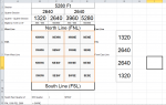
In the US, we have GIS in modern lat/long. But, land titles, rights, and descriptions are based on defined Counties, that contain Townships (36 square miles), that contain Sections (square mile), that are broken up into Quarters (quarter square miles), then into Quarter-Quarters (a quarter of a quarter square mile).
Thomas Jefferson (a dead President) had a program that staked (identified) the corners of each square mile. By Square, it isn't actually square due to that pesky curved Earth plus geographical boundaries like a river or an angry bear den. It is actually mostly square.
This vba code is very "approximate" and qualifies me as a Good Standing Member of the Flat Earth Society.
If you don't understand my attachment, here is a more detailed guide:
http://en.wikipedia.org/wiki/Section_(United_States_land_surveying)
One would expect this surveying formula could be found somewhere. Could not find it anywhere. If anyone has something like this, I would appreciate knowing about it. I have a lot of records to run this against tomorrow.
Code:
Option Compare Database
Option Explicit
Function QuarterQuarter(NSDirection As String, EWDirection As String, NSFt As String, EWFt As String) As String
  ' Rx  Take Feet from boundry in Section (square mile) and determine the QuarterQuarter
      Dim flgNSQuality      As Boolean ' didn't use flags just yet
      Dim flgEWQuality      As Boolean
      Dim flgNSftQuality    As Boolean
      Dim flgEWftQuality    As Boolean
      Dim intNSFT           As Integer
      Dim intEWFT           As Integer
10    On Error GoTo ErrQuarterQuarter
      ' Check the data quality of the input first
20        If NSDirection = "FNL" Or EWDirection = "FSL" Then
30            flgNSQuality = True
40        Else
50            flgNSQuality = False
60            QuarterQuarter = "ErrFNL"
70            Exit Function
80        End If
90        If EWDirection = "FEL" Or EWDirection = "FWL" Then
100           flgNSQuality = True
110       Else
120           flgNSQuality = False
130           QuarterQuarter = "ErrFEL"
140           Exit Function
150       End If
160       If IsNumeric(NSFt) Then
170           If CInt(NSFt) < 0 Or CInt(NSFt) > 5280 Then
180               QuarterQuarter = "ErrNSFtL" ' outside limit
190           Exit Function
200           Else
210             intNSFT = CInt(NSFt)
220           End If
230       Else
240           QuarterQuarter = "ErrNSFt"
250           Exit Function
260       End If
270       If IsNumeric(EWFt) Then
280           If CInt(EWFt) < 0 Or CInt(EWFt) > 5280 Then
290               QuarterQuarter = "ErrNSFtL" ' outside limit
300           Exit Function
310           Else
320             intEWFT = CInt(EWFt)
330           End If
340       Else
350           QuarterQuarter = "ErrNSFt"
360           Exit Function
370       End If

         ' Take the North top row - then go west to east, then east to west
         ' Then take the 2nd North top row
         ' Note: while we cross track E/W (overlap) none of my data had N/S overlap
         ' To complete this code for all possiblities, it would need to double in size
         ' so if a survey went from the southern line north 5200 feet - this wouldn't work
         ' *********** North South *********************************************** EW
380         If NSDirection = "FNL" Then  ' direction From North Line FNL
390           Select Case CInt(NSFt)        ' feet From North
              Case 0 To 1320  ' top North quarter halfs Top Row
400                       If EWDirection = "FWL" Then  ' from West direction top half
410                               Select Case intEWFT        ' feet From N/S Line
                                      Case 0 To 1320
420                                       QuarterQuarter = "NWNW"
430                                   Case 1320 To 2640
440                                       QuarterQuarter = "NENW"
450                                   Case 2640 To 3960
460                                       QuarterQuarter = "NWNE"
470                                   Case 3960 To 5280
480                                       QuarterQuarter = "NENE"
490                                   Case Else
500                                               QuarterQuarter = "ErrNSFt"
510                                               Exit Function
520                               End Select
530                       Else  ' from West direction top half
540                               Select Case intEWFT        ' feet From N/S Line
                                      Case 0 To 1320
550                                       QuarterQuarter = "NENE"
560                                   Case 1320 To 2640
570                                       QuarterQuarter = "NWNE"
580                                   Case 2640 To 3960
590                                       QuarterQuarter = "NENW"
600                                   Case 3960 To 5280
610                                       QuarterQuarter = "NWNW"
620                                   Case Else
630                                               QuarterQuarter = "ErrNSFt"
640                                               Exit Function
650                               End Select
660                       End If

670           Case 1320 To 2640 ' 2nd Row across from North
680                          If EWDirection = "FWL" Then  ' from West direction top half
690                               Select Case intEWFT        ' feet From N/S Line
                                      Case 0 To 1320
700                                       QuarterQuarter = "SWNW"
710                                   Case 1320 To 2640
720                                       QuarterQuarter = "NENW"
730                                   Case 2640 To 3960
740                                       QuarterQuarter = "SWNE"
750                                   Case 3960 To 5280
760                                       QuarterQuarter = "NENE"
770                                   Case Else
780                                               QuarterQuarter = "ErrNSFt"
790                                               Exit Function
800                                   End Select
810                          Else  ' from West direction top half FEL
820                               Select Case intEWFT        ' feet From N/S Line
                                      Case 0 To 1320
830                                       QuarterQuarter = "SENE"
840                                   Case 1320 To 2640
850                                       QuarterQuarter = "SWNE"
860                                   Case 2640 To 3960
870                                       QuarterQuarter = "SENW"
880                                   Case 3960 To 5280
890                                       QuarterQuarter = "NWNW"
900                                   Case Else
910                                               QuarterQuarter = "ErrNSFt"
920                                               Exit Function
930                                   End Select
940                           End If
950           End Select
960       Else  ' can only be FSL From South Line FSL (from bottom)  ******** from southern Line
970           Select Case NSFt        ' feet From North
              Case 0 To 1320  ' Bottom Row
980                          If EWDirection = "FWL" Then  ' from West direction top half
990                               Select Case intEWFT        ' feet From N/S Line
                                      Case 0 To 1320
1000                                      QuarterQuarter = "SWSW"
1010                                  Case 1320 To 2640
1020                                      QuarterQuarter = "SESW"
1030                                  Case 2640 To 3960
1040                                      QuarterQuarter = "SWSE"
1050                                  Case 3960 To 5280
1060                                      QuarterQuarter = "SESE"
1070                                  Case Else
1080                                              QuarterQuarter = "ErrNSFt"
1090                                              Exit Function
1100                              End Select

1110                         Else  ' from West direction bottom row
1120                              Select Case intEWFT        ' feet From N/S Line
                                      Case 0 To 1320
1130                                      QuarterQuarter = "SESE"
1140                                  Case 1320 To 2640
1150                                      QuarterQuarter = "SWSE"
1160                                  Case 2640 To 3960
1170                                      QuarterQuarter = "SESW"
1180                                  Case 3960 To 5280
1190                                      QuarterQuarter = "SWSW"
1200                                  Case Else
1210                                              QuarterQuarter = "ErrNSFt"
1220                                              Exit Function
1230                              End Select
1240                          End If

1250          Case 1320 To 2640 ' 2nd Row from Bottom
1260                         If EWDirection = "FWL" Then  ' from West direction top half
1270                              Select Case intEWFT        ' feet From N/S Line
                                      Case 0 To 1320
1280                                      QuarterQuarter = "NWSW"
1290                                  Case 1320 To 2640
1300                                      QuarterQuarter = "NESW"
1310                                  Case 2640 To 3960
1320                                      QuarterQuarter = "NWSE"
1330                                  Case 3960 To 5280
1340                                      QuarterQuarter = "NESE"
1350                                  Case Else
1360                                              QuarterQuarter = "ErrNSFt"
1370                                              Exit Function
1380                              End Select

1390                         Else  ' from West direction second from bottom south FEL (east to west)
1400                              Select Case intEWFT        ' feet From N/S Line
                                      Case 0 To 1320
1410                                      QuarterQuarter = "NESE"
1420                                  Case 1320 To 2640
1430                                      QuarterQuarter = "NWSE"
1440                                  Case 2640 To 3960
1450                                      QuarterQuarter = "NESW"
1460                                  Case 3960 To 5280
1470                                      QuarterQuarter = "NWSW"
1480                                  Case Else
1490                                              QuarterQuarter = "ErrNSFt"
1500                                              Exit Function
1510                                End Select
1520                          End If
1530           End Select
1540      End If
       ' debug.print  "Made it to the end"
      'QuarterQuarter = "NWNW" ' just for testing
1550  Exit Function
ErrQuarterQuarter:
        MsgBox "trapped error, still needs skined and tanned"
End Function
History
In the US, we have GIS in modern lat/long. But, land titles, rights, and descriptions are based on defined Counties, that contain Townships (36 square miles), that contain Sections (square mile), that are broken up into Quarters (quarter square miles), then into Quarter-Quarters (a quarter of a quarter square mile).
Thomas Jefferson (a dead President) had a program that staked (identified) the corners of each square mile. By Square, it isn't actually square due to that pesky curved Earth plus geographical boundaries like a river or an angry bear den. It is actually mostly square.
This vba code is very "approximate" and qualifies me as a Good Standing Member of the Flat Earth Society.
If you don't understand my attachment, here is a more detailed guide:
http://en.wikipedia.org/wiki/Section_(United_States_land_surveying)